The highest point of Tokyo, this hike up Mt. Kumotori affords a top notch free mountain hut with the best possible view I could think of, and a long ridge hike with easy public transport throughout the year.
Budget: JPY3,180 (~USD31)
When to Go
Anytime during the year, but prepare for a lot of snow in winter.
Special Notes
Saturday
Budget: JPY3,180 (~USD31)
- JPY2,540. Train, Tokyo < > Okutama Station (JPY1,270 one way)
- JPY640. Bus, Okutama Station to Kamosawa.
- February 2-3 2019, January 25-26, 2020
- Difficulty: 4 out of 5, but can definitely be adjusted depending on the trailhead.
- Route below is around 30.8kilometers, with an elevation change of ▲2,741m/ ▽2,925m
Anytime during the year, but prepare for a lot of snow in winter.
Special Notes
- Weather forecast. English / Japanese. English more detailed, Japanese more accurate.
- Trailheads.
- Mitsumine-jinja (三峯神社 ). On the other side of the map above, which I cannot fit into the screenshot anymore. The ascent to the summit from this side was steep, and when we hiked, pure ice. Access as follows:
- Train, Tokyo to Seibu-chichibu Station
- Bus, Seibu-chichibu Station to Mitsumine-jinja
- Kamosawa (鴨沢). I have tried this route and it's just your classic Okutama trail.
- Train, Tokyo to Okutama Station.
- Bus, Okutama Station to Kamosawa. JPY640, 34 minutes one way.
- Mineya (峰谷).
- Train, Tokyo to Okutama Station.
- Bus, Okutama Station to Kamosawa.
- Okutama Station. Starting from Okutama Station might be a challenge given the time restrictions, but definitely possible. The trail passes through a lot of peaks, but the view is amazing.
- Mountain huts.
- Paid. Close to the summit, you'll pass through it if coming from Mitsumine-jinja trailhead.
- Free. A good one right next to the summit.
- Camping. There's a camping spot about an hour away from the summit if coming from Kamosawa or Mineya, and another camping spot close to the paid summit on the side of Mitsumine-jinja.
Saturday
- 09:30am. Bus, Okutama Station to Kamosawa.
- 10:04am. Arrived at Kamosawa Station. Start hike. The hike is pretty straightforward, though we had to put our spikes on halfway. The last push up right before the summit was pretty steep.
- 04:22pm. Arrived at the mountain hut at the top. The summit is still about 30 meters behind the hut.
- 06:00am. Woke up to enjoy the sunrise.
- 06:41am. The ball of fire finally peeked. We had a nice breakfast and headed out.
- 08:20am. Started our descent. (yeah, breakfast and packing took a while)
- 02:30pm. Arrived at Mt. Mutsuishi. The entire descent was a lot of ups and downs, though some sections allow for a bypass.
- 05:00pm-ish. Arrived at Okutama Station! That was a reaaaaally long hike down.
 |
| Arriving at the trailhead, we felt warmly welcomed by Mt. Kumotori! |
 |
| And spent some time taking pictures - at the trailhead! Come on, can you blame us? It's gorgeous. |
 |
| My first every snow hike summit! I've attempted a couple but this is my first marker! |
 |
| Surrounded by snow... |
 |
| Probably the steepest section. |
 |
| Looking back at our footprints. |
 |
| Yey! We got to the summit! |
 |
| My favorite mountain hut, nestled in snow. |
 |
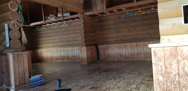
| Inside the hut. There were a couple of people with us, but they left early. |
 |
| A peek outside - and Mt. Fuji is there! Isn't she majestic? |
 |
| Hello, ball of fire! |
 |
| Our view right outside the mountain hut the next morning. |
 |
| Then off to hike we go. |
 |
| Plenty of snow - some of which were a foot or two high. |
 |
| With Mt. Fuji always at sight. |
 |
| Passing through another free mountain hut. |
 |
| Hiking on of the many, many peaks we had to pass to get to Okutama Station. |
 |
| The final descent down. Soon enough, we arrived at the no-snow land, and made our way home. |


Hi! Nice hike! Do you think this hike can be done on a dayhike? I am planning to go this spring. TYIA!!
ReplyDeletehello! For sure can be done as a dayhike. Depends on your route and your speed.
Delete